| Type | Counties | Population | Housing Units | Households | Service | Current |
|---|---|---|---|---|---|---|
The interactive map and tables below give information on the BMSA program by county.
The map shows Alabama's 67 counties. Click on a county for summary information.
This table gives data on Alabama counties. The Service field gives the total number of BMSA recipinets who performed their service requirement in a community in the county, past and present. The Current field gives the number of BMSA recipients (in service or post service) who were working in a community in the county as of 2020. Click on rows in the table to see the corresponding counties highlighted in the map above. Click on a selected row again to de-select and remove the hightlight.
| County | Seat | CBSA | Type | Population | Housing Units | Households | Service | Current |
|---|---|---|---|---|---|---|---|---|
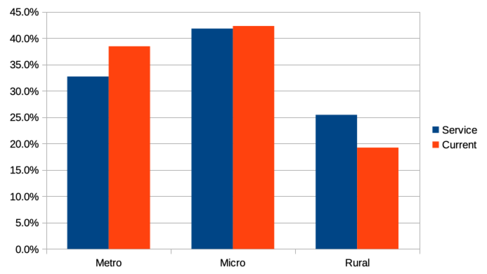
A Core-Based Statistical Area (CBSA) is a US geographic area defined by the Office of Management and Budget (OMB) consisting of one or more contiguous counties (or equivalents). Specifically, CBSA consists of counties anchored by an urban center of at least 10,000 people plus adjacent counties that are socioeconomically tied to the urban center by commuting. The term CBSA refers collectively to both metropolitan statistical areas and micropolitan statistical areas. Micropolitan areas are based on Census Bureau-defined urban clusters of at least 10,000 and fewer than 50,000 people. Metropolitan area are based on a Census Bureau-defined urbanized area of at least 50,000 people. So at the county level, a county in a metropolitan CBSA might be considered predominately urban while a county that is not in a CBSA might be considered thoroughly rural. Counties in a micropolitan CBSA from the gray area, typically with both urban and rural characteristics. The table belows give summary data by county CBSA. Click on rows in the table to see the corresponding counties highlighted in the map above. Click on a selected row again to de-select and remove the hightlights.
| Classificaiton | Counties | Population | Housing Units | Households | Service | Current |
|---|---|---|---|---|---|---|
The table and graph below give summary data by county CBSA type: metropolitan, micropolitan, or rural. Click on rows in the table to see the corresponding counties highlighted in the map above. Click on a selected row again to de-select and remove the hightlights.
| Type | Counties | Population | Housing Units | Households | Service | Current |
|---|---|---|---|---|---|---|